On a section of land adjacent-to and SE of the existing substation.
Maybe
extra transformer capacity being added or other electrical
infrastructure. I'm going to have to visit Google Earth, rather than
Google Maps, as the former has historical satellite imagery.
Edit:
Possibly preliminary groundworks for this: The connection of a "a high-capacity 400 kV
(kilovolt) underground electricity connection between Dunstown
substation in Co Kildare and Woodland substation in Co Meath." This is
part of the Kildare-Meath Grid Upgrade (or Capital Project 966).
Details of necessary works at Dunstown for this project are available here.
A
solar farm has also been granted planning permission at Delamain, just
before Dunstown and adjacent to the road, north of Carnalway Cross. On
the plans for the development, a bay is shown at Dunstown 400 kV
Substation for connection of the 220 kV underground line from the solar
farm.
An
Coimisiún Pleanála still haven't given a decision on the revised plans
submitted for the proposed battery energy storage system (BESS)
facility, as far as I understand it. However, the facility would be
located NE of the substation. More information on the ACP site link
below, and its status is "Live Case". According to an Irish Independent article of 30 August last year, a decision was supposed to have been made by December 2024. The article also said that:
I've added links below to a list of electrical power generating sites in Ireland in a Wikipedia
article, and also written answers from a Dáil Éireann debate of Tuesday, 26
Jan 2010 on the Oireachtais.ie website. There may be sites that generate
lower output, not listed in these resources. According to a list
referred to by Minister Eamon Ryan and provided by EirGrid and ESB
Networks,Athgarvan Grain Company Limited's installation in Athgarvan was generating 20 kW from its small hydro turbine.
(The owner showed me this in 2001, but I can't remember anything
about it). Also Silliot Hill was generating 1.255 MW from methane
produced by the landfill. An installation at Celbridge Mills was listed
as generating 55 kW.
I met Brian Byrne in the Valley Park this morning when out for a walk, and we were musing about how it would be great if there was a turbine that
could generate electricity from the power of the Liffey. It wouldn't have to be a large device, and
could power lights in the park and would be a wonderful demonstration of
the power of water. The problem nowadays is that there's so much red
tape implementing projects like this. Also, as far as I'm aware, land on
both sides of a waterway needs to be owned to install a hydrogeneration system. However, this might only be the case for streams, when a "dam" has to be constructed, potentially flooding fields on the far bank.
I know I'm getting nerdy about this and becoming somewhat obsessed, but let's do some calculations for the total amount of water which has been flowing through the town per day.
Releases of water from Golden Falls dam in Ballymore Eustace have been unusually high over the last week. Some of this water will have flowed through the penstocks (large diameter pipes) to power the alternator and generate electricity. If power from the hydroelectric station can't be accepted by the grid and water level is too high in the lake supplying the dam, it has to "overflow". It's released through "doors" known as sluices, which are raised by electric motors. It then flows down concrete spillways into the river. Flow rate can typically be up to 15 or 20 cubic metres per second (m³/s) during extended periods of rainfall, but over the last couple of days, the rate has peaked at 33 m³/s for periods during the mornings. The ESB provides hydrometric information on their website for several hydro power stations throughout the country. This information consists of head race levels in reservoirs feeding the dams, average daily flow rates and a single set of flow rate figures, which represent projected values at eight-hour intervals throughout the day. At the Golden Falls dam in Ballymore Eustace, average daily flow since 12th December has been 25 m³/s. That's a per second flow rate, but averaged over a whole day. So at times, it was higher than this and lower at other times. For instance, for Thursday 18th December, flow rates were forecast at 20.0, 33.0, 20.0 and 20.0 m³/s, at 00:00 (midnight), 08:00, 16:00 and 00:00 (midnight the next day) respectively.
So to calculate the quantity of water that has been passing through the town over a 24 hour period, simply multiply the flow rate per second by the number of seconds in a day:
Total flow in 24 hours = average flow rate in m³/s x number of seconds in a day
= 25 x 60 x 60 x 24
= 2,160,000 m³
To put that into perspective, it's the volume occupied by a cube with sides 129 m long; the distance from the crossroads in the town centre to Bardon's pub.
In this first part of a two-part tutorial, we'll learn the absolute basics about forces!
What's covered:
Definitions of force, mass, velocity, acceleration, weight
Vector diagrams
Adding and resolving vectors
What Is a Force?
We can think of a force of a force as a push or pull.
What Are Examples of Forces?
When
you lift something off the ground, your arm is exerting a force upwards
on the object. This is an example of an active force.
The Earth's gravity pulls down on an object, and this force is called weight.
A bulldozer can exert a huge force, pushing material along the ground.
A huge thrust is produced by the engines of a rocket lifting it up into orbit.
When you push against a wall, the wall pushes back. If you try to
compress a spring, the spring tries to expand and pushes back against
your hand. When you stand on the ground, it pushes up and supports you.
All these are examples of reactive forces. They don't exist without an active force.
If the unlike poles of two magnets are brought together (N and S),
the magnets will attract each other. However, if two like poles are
moved close together (N and N or S and S), the magnets will repel.
Fundamental Quantities Used in Physics
Before
we learn any more details about forces, we need to become familiar with
the international system of units, abbreviated to SI from the French Système International d’Unités.
It's the units system used for engineering and scientific calculations
and is basically a standardization of the metric system.
3 of the 7 base quantities in the SI system are used in the study of
mechanics (a branch of physics concerned with forces and motion). They
are mass, length and time.
Mass
This is a property of a body (any object) and a measure of the body's resistance to motion known as inertia.
It is constant and has the same value no matter where an object is
located on Earth, on another planet or in space. The unit of mass in the
SI system is the kilo (kg).
Length
In the context of mechanics, the distance travelled by an object. The unit of length or distance is the metre (m)
Time
The time taken for an object to travel a given distance. The unit of time is the second (s)
Derived Quantities
These quantities can be derived from mass, length and time. The basic derived quantities are:
Velocity
This is the speed of a body in a given direction and is measured in
metres per second (m/s). Average velocity equals distance travelled
(length) divided by time taken.
Acceleration
When a force is exerted on a mass, it accelerates.
In other words, the velocity increases. This acceleration is greater
for a greater force or for a smaller mass. Acceleration is measured in
metres per second per second or metres per second squared (m/s²).
Average acceleration equals change in velocity divided by the time the
change occurred in.
Force
This can be thought of as a “push” or “pull.” A force can be active
or reactive. Force equals mass multiplied by acceleration. The unit of
force is the newton (N) (We’ll learn more about this later)
Note: In US English, metres is spelled “meters”.
What One Newton Feels Like
Force in
the SI system of units is measured in newtons (N). A force of 1 newton
is equivalent to a weight of about 3.5 ounces or 100 grams. It's also
defined as the force that will give a mass of 1kg an acceleration of 1
metre per second per second. We'll discover more about this in the
second part of this tutorial.
Different words are used depending on context to refer to the the force involved when a human or machine moves an object. Effort
is often used to refer to the force applied to an object which may
eventually cause it to move. For example, when you push or pull a lever,
slide a piece of furniture, turn a nut with a wrench, or a bull dozer
pushes a load of soil, the applied force is called an effort. When a
vehicle is driven forwards by an engine, or carriages are pulled by a
locomotive, the force which causes motion and overcomes friction and air
drag is known as traction,tractive force or tractive effort. For rocket and jet engines, the term thrust is often used.
Weight
This is the force exerted by gravity on an object. It depends on the
mass of the object and varies slightly depending on where it is located
on the planet and the distance from the centre of the Earth. An object's
weight is less on the Moon and this is why the Apollo astronauts seemed
to bounce around a lot and could jump higher. However it could be
greater on other planets. Weight is due to the gravitational force of
attraction between two bodies. It is proportional to the mass of the
bodies and inversely proportional to the square of the distance apart.
Tensile or Compressive Reaction
When you stretch a spring or pull on a rope, the material undergoes a strain or internal distortion that results in an equal reactive force pulling back in the opposite direction. This is known as tension and is due to stress
caused by displacement of molecules in the material. If you try to
compress an object such as a spring, sponge or gas, the object pushes
back. Again this is due to strain and stress in the material. Working
out the magnitude of these forces is important in engineering so that
structures can be built with members which will withstand the forces
involved, i.e they won't stretch and snap, or buckle under load.
Static Friction
Friction is a reactive force which opposes motion.
Friction can have beneficial or detrimental consequences. When you try
to push a piece of furniture along the floor, the force of friction
pushes back and makes it difficult to slide the furniture. This is an
example of a type of friction known as dry friction, static friction or stiction. Friction can also be a problem in machines and lubrication is necessary to reduce friction between moving parts.
Friction can be beneficial. Without it everything would slide and we
wouldn't be able to walk along a pavement without slipping. Tools or
utensils with handles would slide out of our hands, nails would pull out
of timber and brakes on vehicles would slip and not be of much use. So
we increase friction by putting treads with good grip on the soles of
shoes and grips with knurls or ridges on the handles of tools. Brake
blocks are made from rubber on bicycles. This has a high coefficient of friction to make them grip and slow down wheels when they make contact with the rims.
Viscous Friction or Drag
When a parachutist moves through the air or a
vehicle moves on land, friction due to air resistance, slows them down.
Air friction also acts against an aircraft as it flies, requiring extra
effort from the engines. If you try to move your hand through water, the
water exerts a resistance and the quicker you move your hand, the
greater the resistance. The same thing happens as a ship moves through
water. These reactive forces are known as viscous friction or drag.
Buoyancy Force
This is the force which pushes up on an object immersed in a fluid (a
fluid can be a gas or liquid). So for instance when you push a ball
down into water, you can feel the buoyancy force pushing it back
upwards. You can read more about buoyancy and the Archimedes' principle
in this tutorial: Archimedes' Principle Experiments and Buoyant Force
Electrostatic and Magnetic Forces
Electrically charged objects can attract or repel each other, similar
to how poles of a magnet will repel each other while opposite poles
will attract. Electric forces are used in powder coating of metal and
electric motors work on the principle of magnetic forces on electric
conductors.
When a force is
exerted on a structure or other object, this is known as a load.
Examples are the weight of a roof on the walls of a building, the force
of wind on a roof, or the weight pulling down on the cable of a crane
when hoisting.
What Is a Vector?
A vector is a quantity with magnitude and direction. Some quantities such as mass don't have a direction and are known as scalars. However, velocity is a vector quantity because it has a magnitude called speed
and also direction (i.e., the direction an object is travelling). Force
is also a vector quantity. For example, a force acting down on an
object is different from a force acting upwards on the underside.
Vectors are graphically represented on diagrams by an arrow, with
the angle of the arrow wrt a reference line representing the angle of
the vector. We can solve mechanics problems by drawing vectors to scale
with the length of the arrow representing its magnitude and then adding
the vectors to find unknown forces.
In mechanics, we use free-body or force diagrams
to describe and sketch the forces in a system. A force is usually
represented by an arrow and its direction of action is indicated by the
direction of the arrowhead. Rectangles or circles can be used to
represent masses.
How to Add Vectors
As mentioned
briefly above, a force or any other vector can be represented
graphically by an arrow with a given direction known as a vector. If two
or more forces are involved, problems in mechanics can be solved
graphically by drawing the vectors as a vector diagram, the head of one
vector ending at the tail of the 2nd vector and so on. The vectors are
drawn to scale, the length representing the magnitude of a force and the
angle being the angle of action of the a. The "Triangle of Forces" or
"Parallelogram of Forces" is then a method for visualizing or finding
the resultant of forces. The resultant vector from adding force vectors
gives the magnitude and direction of two or more forces combined.
Vector Algebra: The Triangle of Forces
We can add forces graphically using a triangle of forces.
When a body is under equilibrium of three forces acting at a point, the
forces can be represented by the sides of a triangle taken in order.
We can also sum forces using a parallelogram of forces. In the
diagram below, one dotted side is drawn parallel to F1 and the other
dotted side parallel to F2. A line is drawn joining the start of vectors
F1 and F2 to where the two dotted sides intersect. This line represents
the sum of the two forces F1 and F2.
We can also resolve
or split up a force into two or more forces. This is like using the
parallelogram of forces in reverse. In the diagram below, a mass rests
on a slope. Using the parallelogram of forces in reverse, the weight
force can be resolved into a force parallel to the slope and
perpendicular to the slope. This is useful for these type of problems
because it enables the normal reaction to be worked out (the reactive
force exerted by the slope on the mass, due to the perpendicular
component of the mass, F2, acting on the slope). F1 is the force acting
down the slope. If the mass isn't moving, F1 is balanced by a static
friction force acting up the slope.
Using the Parallelogram of Forces to Resolve Weight Into Normal and Tangential Forces
In the second part of this tutorial, we'll cover Newton's Three Laws of Motion for Beginners. This explains in more detail what happens to an object when a force acts on it.
Applied Mechanics by John Hannah and M.J. Hillier is a standard text book for students taking Diploma and Technician
courses in engineering. It covers the basic concepts I briefly cover in
this article as well as as other topics such as motion in a circle,
periodic motion, statics and frameworks, impulse and momentum, stress
and strain, bending of beams and fluid dynamics. Worked examples are
included in each chapter in addition to set problems with answers
provided.
Mathematics
Engineering Mathematics by K.A. Stroud and Dexter J. Booth is an excellent math textbook for both engineering students and anyone
with an interest in the subject. The material has been written for part 1
of BSc. Engineering Degrees and Higher National Diploma courses.
A wide range of topics are covered including matrices, vectors,
complex numbers, calculus, calculus applications, differential
equations, series, probability theory, and statistics. The text is
written in the style of a personal tutor, guiding the reader through the
content, posing questions, and encouraging them to provide the answer.
This book basically makes learning mathematics fun!
References
Hannah, J. and Hillerr, M. J., (1971) Applied Mechanics (First metric ed. 1971) Pitman Books Ltd., London, England.
This article is accurate and true to the best of the author’s knowledge.
Content is for informational or entertainment purposes only and does
not substitute for personal counsel or professional advice in business,
financial, legal, or technical matters.
Mechanics is a branch of physics which deals with forces, mass, and motion. In this second part of a two part tutorial, you'll learn the absolute basics! In the first tutorial, Examples of Forces in Everyday Life and How They Affect Things, we learned what force is and explored the various types of forces in the world around us.
What's Covered in This Guide?
Newton's three laws of motion and how an object behaves when a force is applied
In
the 17th century, the mathematician and scientist Isaac Newton came up
with three laws of classical mechanics concerning motion of bodies in
the Universe. These laws describe the relationship between the motion of
an object and the forces acting on it. In physics, objects have a
property called mass, measured in kg in the SI system (This stands for Système International d'Unités, the standard system of units used in science and engineering)
1. Newton's First Law of Motion: Rest or Uniform Motion
Basically,
this means that if for instance a ball is lying on the ground, it will
stay there. If you kick it into the air, it will keep moving. If there
was no gravity, it would go on for ever. However, the external force, in
this case, is gravity which causes the ball to follow a curve, reach a
max altitude and fall back to the ground. Friction from air also slows
it down.
Another example is when you put your foot down on the
accelerator and your car increases in speed. When you take your foot off
the accelerator, the car slows down, The reason for this is that
friction at the wheels and friction from the air surrounding the vehicle
(known as drag) causes it to slow down. If these forces were magically
removed, the car would stay moving forever. There are three scenarios for the first law: Two for when a body is at rest and one for when it's in motion.
Body at Rest
There are two scenarios for a body at rest:
Scenario 1: No forces acting on the body
In
the example of a body floating in deep space, far from any planets or
stars, where it isn't influenced by gravity, it will stay in this
position at rest forever. In reality of course, it will always be
influenced by gravity, even at huge distances, although the effect may
be tiny. In the diagram below, the body is given the symbol m,
representing its mass. The body doesn't have to be in space of course,
but this is an extreme example of a body so remote, that there are
extremely small forces acting on it.
In
reality, there will always be forces acting on a body. If forces cancel
out, there's no net force acting and again it stays at rest. An example
is an object with mass m suspended from a rope. The force of gravity
pulls down on the object. However the rope also pulls back up with a
tension force. These forces cancel each other out and there's no net
force.
This is
the 3rd scenario of Newton's 1st law. When a body is acted on by a net
force, it accelerates and reaches a certain velocity. When that force is
removed, it continues to travel at that velocity, unless another force
acts on it. Again, the reason why we don't see this ideal behaviour
happening in the real world and objects continuing to move without
slowing down is because external forces act, usually friction and drag
due to air. We see approximations though, so a spinning top will spin
for a long time if it has a pointed foot that has little friction wit
the surface on which it rests. Similarly a bowling ball or marble will
roll a long way on a hard level surface without stopping.
2. Newton's Second Law of Motion: Force and Acceleration
This
means that if you have an object and you push it, the acceleration is
greater for a greater force. So for example a 400 horse power engine in a
sports car is going to create loads of thrust at the axle and
accelerate the car to top speed much more rapidly than a regular engine
would be capable of achieving with the same weight of car.
In the
SI system of units, force is measured in Newtons (N), mass is measured
in kilograms (kg) and acceleration is measured in metres per second per
second (also known as metres per second squared) (m/s2)
So:
If F is the force in Newtons (N)
m is the mass in kilos (kg)
and a is the acceleration (m/s2)
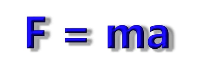
Then we can write an equation for Newton's 2nd law:
F = ma
This
tells us that the mass of a body multiplied by its acceleration equals
the force applied to that body that gave it the acceleration a.
We can also rearrange the equation so
a = F / m
What does this equation tell us?
Acceleration is proportional to the applied force
So the acceleration is directly proportional to the applied force. Double the force F and a doubles. Triple the force F and a is tripled and so on.
Acceleration is inversely proportional to the mass
For larger masses, acceleration is smaller for the same force. So for example, In the equation above if we double m, a is halved.
Imagine
in the example above that the sports car engine was placed into a heavy
train locomotive and could drive the wheels. Because the mass of the
locomotive is so large, the force creates much lower acceleration and
the locomotive takes much longer to reach top speed (In the equation, F is the same, but m is below the line, so a is smaller).
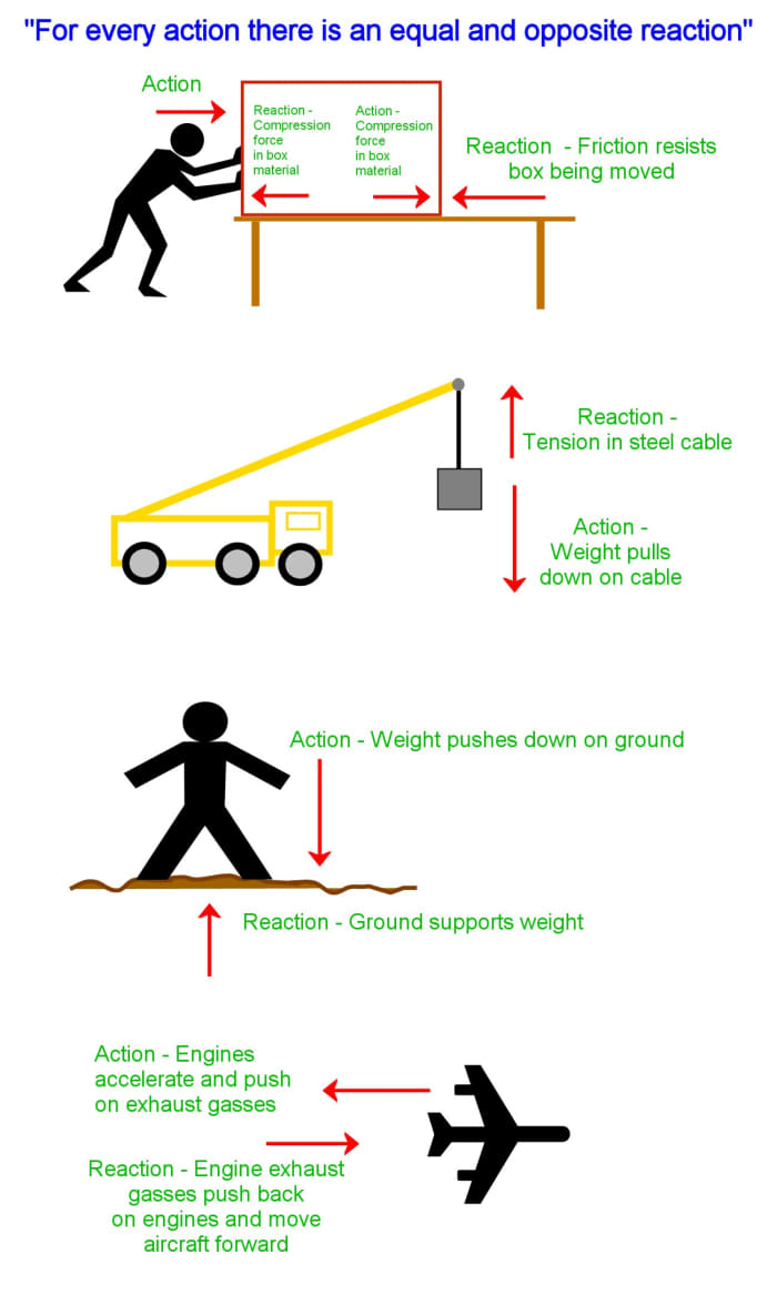
3. Newton's Third Law of Motion: Action and Reaction
This means that when a force is exerted on an object, the object pushes back.
Some examples:
When you push on a spring, the spring exerts a force back on your hand. If you push against a wall, the wall pushes back.
When you stand on the ground, the ground supports you and pushes
back up. If you try to stand on water, the water cannot exert enough
force and you sink.
Foundations of buildings must be able to support the weight of the
construction. Columns, arches, trusses and suspension cables of bridges
must exert enough reactive compressive or tensile force to support the
weight of the bridge and what it carries.
When you try to slide a heavy piece of furniture along the floor,
friction opposes your effort and makes it difficult to slide the object
As
we saw above, friction is an example of a force. When you attempt to
slide a piece of furniture along a floor, friction opposes your effort
and makes things more difficult. Friction is an example of a reactive
force, and doesn't exist until you push the object (which is the active
force). Initially, the reaction balances the applied force i.e. your
effort pushing the furniture, and there is no movement. Eventually, as
you push harder, the friction force reaches a maximum, known as the limiting force of friction.
Once this value is exceeded by the applied force, the furniture will
start to slide and accelerate. The friction force is still pushing back
and this is what makes it so difficult to continue to slide the object.
This is why wheels, bearings, and lubrication come in useful as they
reduce friction between surfaces, and replace it by friction at an axle
and leverage to overcome this friction. Friction is still necessary to
stop a wheel sliding, but it doesn't oppose motion. Friction is
detrimental as it can cause overheating and wear in machines resulting
in premature wear. So engine oil is important in vehicles and other
machines, and moving parts need to be lubricated.
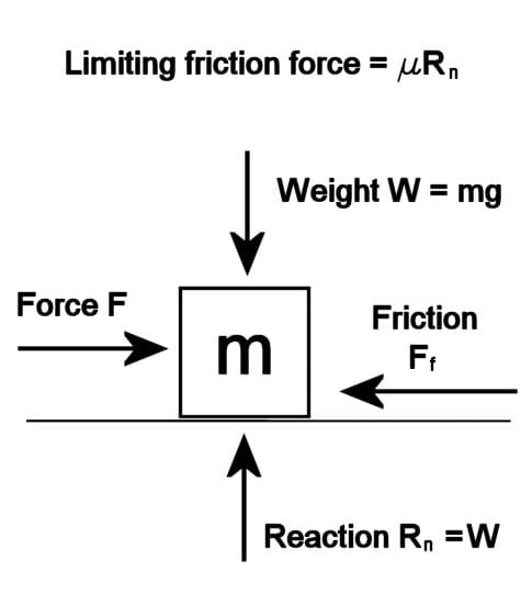
Dry static friction, also known as stiction (see above diagram)
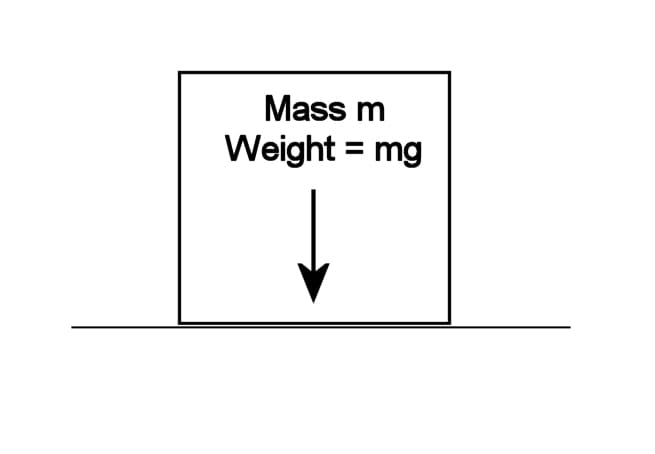
If F is the applied force on a body
The mass of the body is m
Weight of the body is W = mg
μs is the coefficient of friction (low μ means the surfaces are slippery)
and Rn
is the normal reaction. (the reaction force acting upwards at right
angles to the surface due to the weight of the object acting downwards)
If the surface is horizontal, then
Reaction Rn = Weight W
Then
limiting friction force is Ff = μsRn = μsW = μsmg
Remember
this is the limiting force of friction just before sliding takes place.
Before that, the friction force equals the applied force F trying to
slide the surfaces along each other, and can be anything from 0 up to μRn.
So
the limiting friction is proportional to the weight of an object. This
is intuitive since it is harder to get a heavy object sliding on a
specific surface than a light object. The coefficient of friction μ
depends on the surface. "Slippery" materials such as wet ice and Teflon
have a low μ. Rough concrete and rubber have a high μ. Notice also that
the limiting friction force is independent of the area of contact
between surfaces (not always true in practice)
Kinetic Friction
Once
an object starts to move, the opposing friction force becomes less than
the applied force. The friction coefficient in this case is μk.
What Are Newton's Equations of Motion? (Kinematics Equations)
There
are three basic equations which can be used to work out the distance
travelled, time taken and final velocity of an accelerated object.
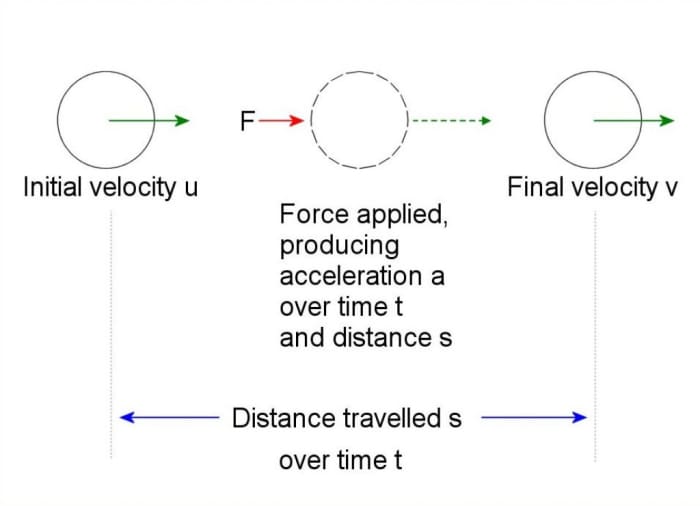
First let's pick some variable names:
u is the initial velocity
v is the final velocity
s is the distance covered
t is the time taken
and a is the acceleration produced by force F
As long as the force is applied and there are no other forces, the velocity u increases uniformly (linearly) to v after time t.
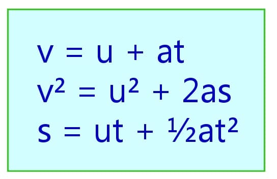
So for uniform acceleration we have three equations:
v = u + at
s = ut + 1/2 at2
v2 = u2 + 2as
Examples:
(1)
A force of 100 newtons accelerates a mass of 5 kg for 10 seconds. If
the mass is initially at rest, calculate the final velocity.
Firstly it is necessary to calculate the acceleration.
F = 100 newtons
m = 5 kg
F = ma so a = F/m = 100/5 = 20 m/s2
Next work out the final velocity, knowing the acceleration:
Substitute for u, a and t:
u = initial velocity = 0 since the object is at rest
a = 20 m/s2
t = 10 s
v = u + at = 0 + 20 x 10 = 200 m/s
(2) A mass of 10 kg is dropped from the top of a building which is 100 metres tall. How long does it take to reach the ground?
In
this example, in theory it doesn't make any difference what the value
for the mass is, the acceleration due to gravity is g irrespective of
the mass. Galileo demonstrated this when he dropped two balls of equal
sizes but differing masses from the leaning tower of Pisa. However in
reality, the drag force due to air resistance will slow down the falling
mass, so a 10 kg sheet of timber would fall slower than a 10 kg lead
weight. So assume there is no drag and the calculations apply to a
weight falling in a vacuum.
We know s = 100 m
g = 9.81 m/s2
u = 0 m/s
We can use the equation s = ut + 1/2 at2
The acceleration a in this case is the acceleration due to gravity so a = g
Therefore substituting for u and g gives
s = 0t +1/2 gt2 s = 1/2gt2
Rearranging
t = √(2s/g) = √(2 x 100) / 9.81 = 4.5 seconds approx
Applied Mechanics by John Hannah and MJ Hillier
is a standard text book for students taking Diploma and Technician
courses in engineering. It covers the basic concepts I briefly cover in
this article as well as as other topics such as motion in a circle,
periodic motion, statics and frameworks, impulse and momentum, stress
and strain, bending of beams and fluid dynamics. Worked examples are
included in each chapter in addition to set problems with answers
provided.
Mathematics
Engineering Mathematics by K.A. Stroud
is an excellent math textbook for both engineering students and anyone
with an interest in the subject. The material has been written for part 1
of BSc. Engineering Degrees and Higher National Diploma courses.
A
wide range of topics are covered including matrices, vectors, complex
numbers, calculus, calculus applications, differential equations,
series, probability theory, and statistics. The text is written in the
style of a personal tutor, guiding the reader through the content,
posing questions, and encouraging them to provide the answer.
This book basically makes learning mathematics fun!
References
Hannah, J. and Hillerr, M. J., (1971) Applied Mechanics (First metric ed. 1971) Pitman Books Ltd., London, England.
If you liked this article, you may be interested in reading more articles about mechanics:
This
content is accurate and true to the best of the author’s knowledge and
is not meant to substitute for formal and individualized advice from a
qualified professional.
A discussion on RTÉ Liveline today was about "Airsoft" type guns on public display in shops. Under the Firearms Acts 1925, revised to 2023, these guns must have a muzzle energy of less than 1 joule to avoid being classified as firearms requiring a license.
What's a joule?
It's the Système International (SI) unit of energy or work done.
Energy = power x time
So 1 watt for 1 second = 1 x 1 = 1 joule.
Think of a 1 watt bulb turned on for 1 second; that consumes 1 joule of energy.
Since energy can't be created or destroyed (except in nuclear reactions where there are mass-energy conversions), "consumes" doesn't mean the bulb destroys the energy, it's simply converted into another form of energy, light and heat. For an incandescent bulb, 95% of the energy is heat.
Another example of a joule is the work required to lift a weight. Work in physics has a very specific meaning. It's defined as something which occurs when a force moves a body through a distance. When an object is lifted off the ground, a force is required to counteract the force of gravity.
The work done W when a force moves a mass m a distance h above the ground is defined as:
W = mgh
if m is 1 kilo and h is 10 cm (0.1 m)
and g is the acceleration due to gravity; approximately 9.81 metres per second per second
W = 1 x 9.81 x 0.1 = 0.981 or approximately 1 joule.
So that's the amount of energy an Airsoft pellet is limited to; the potential energy of a bag of sugar, raised 10 cm off the ground. (or 100 g, raised 1 m off the ground). Contrast that with the energy of a rifle bullet, which is approximately the potential energy of a brick raised to the height of a chimney on a two story house.
Did
you know, some gasses have a colour (like chlorine), many are invisible
and have have no taste or smell (such as oxygen and nitrogen), and yet
others are totally unreactive—the noble gasses, such as neon, argon and
xenon? Also steam is an invisible gas. The stuff we see coming out of a
kettle is condensed steam, but close to 100 degrees Celsius.
In this episode, Mark Miodownik – Professor of materials and society at
the University College London and the author of It’s a Gas: The Sublime
and Elusive Elements That Expand Our World, talks with executive
producer of BPS, Molly Bentley.
"Sides of pork, brooms, Cadbury chocolate and cocoa and The Freeman's Journal: some of the items for sale in Kilcullen circa 1900."
I've been examining photos from the Lawrence Collection again and zooming in to see whether I can spot any details I may have missed. The collection is available online on the National Library of Ireland's website. I first viewed the photographs on a visit to the NLI around 1982. In those days, before digitisation, photographic records were stored on rolls of microfilm and had to be viewed using optical microform readers. The Lawrence Collection consists of approximately 40,000 glass plate negatives of buildings and scenes from life in Ireland, photographed between 1865 and 1914. The photographs were taken using large-format cameras and because of the size of the glass-plate negatives, resolution is quite high. There are 25 photographs of buildings and streetscapes in Kilcullen and its hinterland, and the collection became available to access online over 10 years ago.
So being a member of 60 Facebook groups and squandering a lot of time nattering about all sorts of things, I try to get at least one useful thing done per day. Today was damp, so dealing with weeds in the driveway was out of the question. One of the items on my ever-growing-longer "to do" list I hadn't got around to was fixing the wheel on my hand truck which always seemed to be soft when I went to use the truck. I thought it might be a puncture caused by running over thorns (what usually happens with the bike). However doing a water test showed the Schrader valve was leaky. There's a special tool for taking the innards out of the valve casing, but I usually just use a needle-nose pliers. These valves have a conical part that sits into a conical seat, the cone being pressed against the seat by a spring. I blew out the valve with compressed air, gave the red ring that seals against the valve body a wipe and put the bits back together. This time there were no leaks whatsoever after the water test.