![]() |
| Created with Grok Imagine |
Edit: Grok made the image, so send the Grammar Police to them if you're concerned about spelling.
![]() |
| Created with Grok Imagine |
![]() |
| AI image created by Grok for illustrative purposes. |
![]() |
| © Eugene Brennan |
![]() |
| A counterbalance used to balance a lever. These are often seen on road barriers where one end of the lever is much shorter than the other end. © Eugene Brennan |
Standing at the side of the parish church this morning, collecting for the SVP, I noticed the parish centre still has sash windows. I’m not sure whether these are the original ones; I would have thought they’d have rotted away by now. So maybe some or all of them are timber replacements. As six-year-olds in Sr Brendan's senior infants or "high infants" as we called it, one of the chores that was sought after was being allowed to sweep the leaves on the lane up to the playing field, where the Millstream Court houses are now located. The other was being given the job of opening or closing the sash windows in the classroom. In our young minds, either of these tasks gave us a sense of being very important people.
![]() |
| Generated using Bing Image Creator |
Did you know, you can register for an ESB Networks account that allows you to access lots of information about the electricity usage logged by your smart meter, irrespective of which supplier you're with? The details are more comprehensive than those provided by electricity providers. Also, meter readings are shown and it's possible to download a comma separated values (CSV) file that contains meter readings which can be read by spreadsheet software such as Excel. Time and date-stamped daily readings are provided, with a precision of two decimal places. I switched to SSE Airtricity recently and was annoyed to discover that their bills don't show meter readings, just usage. So there's no way to double check whether the figure they quote tallies with meter readings.
The
Artemis I mission, launched in 2022, involved sending an uncrewed Orion
spacecraft into orbit around the Moon and bringing it back to Earth.
Artemis II will be a crewed mission, launching four astronauts into a
free-return orbit around the Moon and back to Earth, the first time
humans will have been in lunar orbit since 1972. The mission had been
delayed until September 2026 due to technical problems, but has now been
brought forward to April of next year or possibly earlier. NASA's Orion
spacecraft comprising of a command and service module sits on top of
the unimaginatively-named Space Launch System (SLS), the equivalent of
the Saturn V rocket used for the Apollo program. The 8.4 m (27.6 ft)
diameter, 98 m (322 ft) tall SLS is a two-and-a-half-stage rocket,
powered by engines that burn liquid hydrogen and liquid oxygen, assisted
by two solid rocket boosters.
Artemis II crew. Image credit: NASA/Kim Shiflett
![]() |
| Twin 220 kV lines crossing the mountains from Turlough Hill hydro station. © Eugene Brennan |
![]() |
| Image © Google Maps |
![]() |
| Image © Google Maps |
![]() |
| Image © Google Maps |
![]() |
| Ladder logic program. © Eugene Brennan |
![]() |
| Historical buildings in Ballitore and Calverstown.© Eugene Brennan |
My Sunday cycle this week was supposed to be to Kilkea Castle, but it was 4 pm by the time I set out and I changed plans midway. (Sometimes I make up the route as I go along and let the bicycle decide). Usually on the steep road out of Crookstown heading west towards the Athy road direction, I turn left for Mullaghmast at the top of the hill. I travel cross country to Kilkea this way, crossing the new N78 Athy Link Road at the bottom of Mullaghmast Hill, and then take a right just before the Moone Inn. On Sunday, I took the second turn after the Mullaghmast turn on the Crookstown road. This leads to the Burtown area on the new N78. I travelled a few miles east on the N78, and then exited for Ballitore. In the village I took some photos of the historic Quaker buildings including the Meeting House and Mary Leadbeater's house, now a library and museum. Leadbeater (1758 - 1826 ) was a Quaker and author who lived in the village and documented events during the 1798 rebellion.
![]() |
| Mary Leadbeater's house, now a library and museum. © Eugene Brennan |
![]() |
| A school established in 1726 by Abraham Shackleton. It's now a Quaker meeting house. © Eugene Brennan |
Next I headed to the outskirts of the village and the location of Ballitore Mill. This a large, ruined structure, built in the early 19th century. An EPA hydrometric station that monitors water level and flow is located on the River Griese, which runs alongside the mill. The Griese in addition to powering this mill also powered a second mill in Ballitore, located down a cull-de-sac in the village. I headed back on the old section of road towards Crookstown. This was the original Carlow road before it was replaced by a wider section several decades ago. It's amazing how the ditches of a road that's no longer used begin to creep inwards and the accumulation of leaves and other debris begin to return it to nature, obscuring the tarmac.
![]() |
| Ballitore Mill. © Eugene Brennan |
![]() |
| Ballitore Mill. © Eugene Brennan |
![]() |
| EPA hydrometric station. © Eugene Brennan |
From Crookstown, I headed back towards Calverstown via Narraghmore Bog. I took the road that runs alongside Crookstown Millview AC's track and then turned off that to pickup up the Narraghmore - Calverstown road. I've always intended to visit Blackhall Castle, and I've passed the entrance multiple times over the decades, so I decided to investigate it on Sunday. A long, wooded lane leads down to the castle, situated in the grounds of an old farmhouse, probably dating to the Georgian period and owned by Jeffrey and Naomi White. The owner, Naomi, and a barking Cocker Spaniel greeted me and Naomi explained some details about the ruin. The four story castle was built by the Eustace family in the 16th century and appears to have a large , impressive fireplace on the fourth floor. Unfortunately half of the castle collapsed in 1999, due to instability in the structure. Naomi told me they had secured a grant to stabilise the structure, but it's a shame the collapse happened before this work could be done. There's also a "Sheela na Gig" carving which was luckily recovered from the rubble after the collapse and is now mounted in a ground floor wall. More information on Blackhall Castle is available on the Irish Historic Houses blog here.
![]() | |
| Blackhall Castle. © Eugene Brennan |
![]() |
| Blackhall Castle. © Eugene Brennan |
![]() |
| Sheela na gig carving. © Eugene Brennan |
![]() |
| My cycle route. © Eugene Brennan |
![]() |
| Items found in the garden. © Eugene Brennan |
![]() |
| Cleaning a paint brush in white spirit. © Eugene Brennan |
I've been painting my front door, something I've been putting off for a couple of months. Painting requires preparation and then there's all the cleaning up to do afterwards. The trend now is towards the replacement of oil-based paints for wood and metal by water-based formulations. Presumably this is an eco-driven thing, to reduce emissions of volatile organic compounds (VOCs) into the atmosphere or landfills when paint containers are discarded. I'm not convinced water-based paint is as durable as oil-based types, however it does make the cleaning of brushes easier.
![]() |
| Shiny fittings on the newly-painted front door, the result of hours of polishing. © Eugene Brennan |
![]() |
| Image courtesy and © Tailte Éireann. |
I was late as usual heading out on my Sunday cycle, and this week it was a relatively short trip to Sallins after the long cycle to the Glen of Imaal the previous weekend. My sister had informed me that the De Burgh Woodland Gardens were open again this year. The woodland area, located just off the Sallins Road on Mill Lane and once part of the De Burgh Oldtown estate, has been developed over the last couple of years by Kildare County Council, the land having been transferred to Naas Town Council in 2011. I guessed the gardens would probably close around 5 pm and sure enough when I got there at 4:40 pm, I only had five minutes to walk the trails by the time I got my bike locked, and removed bags and lights and all the other stuff that could easily be stolen. I didn't get a chance to take any photos, but the place looks nice, although quite dark because of the tree canopy. It is woodland of course, although there's a pond at one end, which I didn't manage to see. As usual when I visit these places, I often investigate the area the next day on Google Maps and Tailte Éireann's Irish Townlands and Historical Map Viewer to find out the historical function of some of the structures I might have noticed. On 19th century maps, a large rectangular pond existed to the right of the entrance to the park. From satellite imagery this seems to be overgrown and from what little can be seen on Street View over the wall from the vantage point of Mill Lane, it appears marshy and populated by irises. The pond was fed from a mill race or stream that originated on the Ballymore Road and this is still in existence. On the c.1900 25" OSI map, the mill race is shown running alongside the Union Workhouse (now the old part of Naas Hospital). This is the stream that was dammed to create the lakes at Lakelands. The mill race then continued to Corban's Mill (located near what was Lawlor's Ballroom) providing power to it before taking a sharp left, running under Corban's Lane and at the back of St. David's Castle. From there, it ran alongside what is now the John's Lane car park (which used to be the Superquinn overflow car park), before becoming a culvert running beneath main street and emerging to the surface a couple of hundred metres away at McCauley Place. From there, it continued parallel to the Sallins road towards a corn mill (with associated mill pond), shown as "Fryar's Mill" on the 25" map, before running under Mill Lane into the De Burgh Woodland Gardens.
![]() |
| Image courtesy and © Tailte Éireann. |
![]() |
| Image courtesy Google Maps. |
The Kildare County Council owned De Burgh Woodland Gardens are open Thursday to Sunday, April – October, 9am – 5 pm. More information here.
Map images courtesy and © Tailte Éireann.
![]() |
| A woodland trail in the gardens. © Eugene Brennan |
![]() |
| © Eugene Brennan |
![]() |
| © Eugene Brennan |
![]() |
| © Eugene Brennan |
![]() |
| © Eugene Brennan |
The L8333 road from Hollywood to Donard runs parallel to the N81 and through the picturesque Hollywood Glen. It's is one of my favourite places in west Wicklow, lined on both sides by tall pine trees and rocky crags in places. A planning application has been lodged recently to Wicklow County Council on behalf of Wicklow Renewables Ltd for a solar PV development and battery energy storage system (BESS) facility in the area. According to the planning application, the site will cover an area of ca. 65.4 ha and consist of an array of solar panels, 192 BESS units comprising 22 modules, a 38 kV substation and other ancillary works. The location of the proposed solar development is on raised ground behind the treeline in the photo below. The boundary of the proposed development extends southwards and to the west towards the N81.
![]() |
| Hollywood Glen. © Eugene Brennan |
![]() |
| Notice about planning application by Wicklow Renewables Ltd. © Eugene Brennan |
Apart from the Modubeagh and Gracefield coal mines near Wolfhill, one of the nearest mines to Kilcullen was the Deerpark Colliery near Castlecomer, which opened in 1924. Anthracite, a high carbon coal, also known as "Kilkenny Coal" and used before coke for ore smelting, was extracted from the mine. This was transported on a dedicated branch line that ran through Castlecomer and joined the Waterford & Maryborough branch of the GS&WR, itself a branch of the Dublin to Waterford rail line. The Deerpark colliery closed in 1969. The region south of Ballylinan, (located 6 km south of Athy) including parts of counties Laois, Carlow and Kilkenny, is riddled with the remnants of now closed coal mines. These mines tapped into several anthracitic formations that are part of the Leinster Coalfield. Mining has also taken place in Wicklow since ancient times and one of the most well known mining areas is around Avoca, where sulphur, lead and copper were extracted. Lead was mined at Glendalough and also in its sister valley, Glendasan.
A useful resource is the OPALS (Online Prospecting Application Licensing System) interactive webmap, from the Department of the Environment, Climate and Communications, which provides locations and information on historical and current mineral exploration and mining in Ireland.
![]() |
| OPALS (Online Prospecting Application Licensing System) interactive webmap. Image courtesy and © Tailte Éireann |
Halfway between Hollywood and Donard and now overgrown with briars and lady ferns is what appears to be the entrance to an adit. The adit is partially flooded and the echo of water dripping from the roof can be heard. While a mine shaft is a vertical structure, an adit is a horizontal passage that extends sideways into a mine. This is marked on the c. 25" OSI map and is denoted as "Spa Hole" and "Iron Mine Disused". I haven't been able to find any information so far on this working, other than a geological report on the glen that indicates it's a glacial feature, deeply carved by high-energy, water run-off as ice melted. The second map below from Geological Survey Ireland shows audited sites, with links to reports accessible by clicking the link in the pop-up.
![]() |
| Entrance to Spa Hole adit. © Eugene Brennan |
![]() |
| "Spa Hole" marked on 25" OSI map. Image © Tailte Éireann |
![]() |
| Audited Geological Heritage. Image © Tailte Éireann Geological Survey Ireland |
![]() |
| © Eugene Brennan |
My second long cycle of the year was an 80 km / 50 mile loop on Sunday that took in a section of the Barrow Way. This is a walking and cycling trail along the Barrow Branch of the Grand Canal and River Barrow that stretches a distance of 117 km, from Robertstown in County Kildare, to St. Mullins in County Carlow. My cycling route was cross-country to Athy via Narraghmore Bog, Mullaghmast and the new N78. Then along the Barrow Way from Athy to Vicarstown and back home via Kilberry Bog, the outskirts of Suncroft and Ballysax. Grit trails have been laid along the canal banks in the last decade or so to make cycling and walking easier.
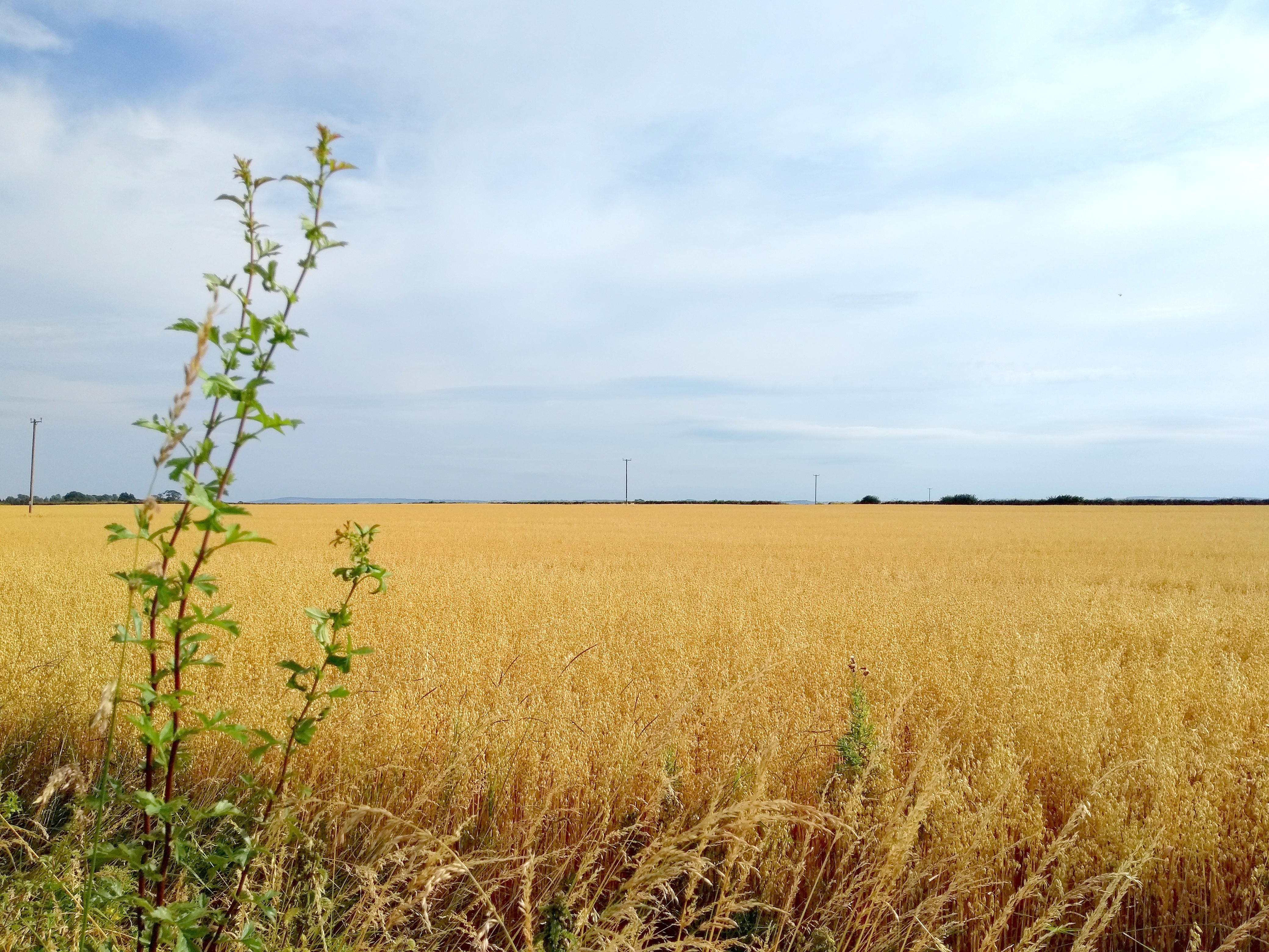
Kildare is a flat county, but the region of south Kildare and County Laois near Athy is characterised by exceptionally large, flat, open fields, almost prairie-like, cultivated with barley in the summer. The golden brown of the corn contrasts with the "big skies" and unobstructed views of the horizon.
![]() |
| © Eugene Brennan |
Apart from admiring the scenery along the Barrow Way, I spotted some interesting engineering features. The first was the Camac Aqueduct at Derrybrock in County Laois. This is a three-arched aqueduct, built over the Stradbally River in 1790, to carry the Barrow Branch of the Grand Canal. As far as I know, marl, a soft grey clay, found at the bottom of bogs, was used as a sealer for waterproofing the masonry joints of aqueducts. In the documentary series Hands, marl was also used by one of the operators of Powers Foundry in New Ross for lining the furnace to prevent the casing from being burned by the intense heat. The Camac Aqueduct seemed "leaky", water dribbling from the top of the arches. Maybe this is normal for these structures.
![]() |
| Camac Aqueduct in County Laois. © Eugene Brennan |
At Derrybrock Bridge near Vicarstown, I came across an OPW hydrometric measuring station, similar to the Kildare County Council owned and EPA managed one at the Mill Stream bridge on the Mass Path in Kilcullen. While the monitoring apparatus in Kilcullen is somewhat low-key and wouldn't be noticed by the casual walker, the station at Derrybrock is more obvious. A large, and what appears to be a broad-crested, flat-V weir, similar to the one in Kilcullen is used to backup the water so that it rises in level. The monitoring equipment, powered by a solar panel, projects out of the side of the riverbank. The "V" in this weir is more obvious than the one in Kilcullen, with the arms of the "V" rising up out of the water on both sides. Various types of profiles are used for weirs: rectangular, parabolic, trapezoidal, flat-V and V-notch, each having their advantages and disadvantages. Flat-v weirs are used for measurements in rivers and streams with low flow rates and narrow stream beds. Some info on the different types and flow calculations here. As I explained in the article about the Mill Stream hydrometric station in Kilcullen, weirs are used for measuring water flow. A weir causes water in a stream or river to backup and rise in level. By measuring the level using an ultrasonic or pressure transducer and doing some calculations, flow rate can be worked out. This hydrometric data can then be used for planning, water management, flood research etc. Information on the EPA's hydrometric programme is available here. It's part of the National Hydrometric Programme, with other bodies such as the OPW, the ESB and Waterways Ireland also involved in measuring water level and flow. Data from a network of over 1000 hydrometric stations around the country can be viewed on the EPA's Hydronet website.
![]() |
| Derrybrock Hydrometric Station. © Eugene Brennan |
![]() |
| Instrumentation for measuring water level. © Eugene Brennan |
![]() |
| Flat-V weir. © Eugene Brennan |
![]() |
| Flat-V weir. © Eugene Brennan |
![]() |
| Weir view from Derrybrock Bridge. © Eugene Brennan |
![]() |
| Lifebuoy in the Valley Park, Kilcullen. © Eugene Brennan |
I've just been thinking about these. There are three lifebuoys on the west bank of the river: one at the low section of river bank near the bridge, another further up opposite the canoe club building and the third is on a section of river bank that's high above water level, just before St. Brigid's Well. There aren't exactly any points near the river to safely throw the lifebuoys without slipping. For the middle buoy, the slope is steep and slippery and there's just a small muddy patch near the water's edge. The grass here seems to be flattened, possibly from people making their way down to the edge to fish or to allow dogs to swim in the river. Or perhaps KCA have cut the grass for access.